About

Painter & Decorator


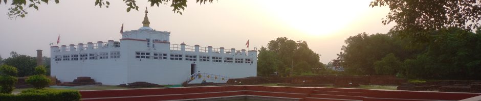
In Buddha’s Footsteps

Buddhism

Category Archives: Bivy Bag
Cowleaze Wood – Oxfordshire
Cowleaze Wood is the county top of Oxfordshire. Oxfordshire’s county top is within Cowleaze Wood; the wood itself though is relatively flat, and placing the exact top can be a challenge, but it lies on a footpath through the heart of the … Continue reading
Posted in Bivy Bag, County Tops, Extreme Points
Comments Off on Cowleaze Wood – Oxfordshire
Ebrington Hill Shoulder – Warwickshire
Ebrington Hill Shoulder is the county top of Warwickshire. The very top of Ebrington Hill is in Gloucestershire; Warwickshire’s highest point is at the county border some yards to the South East. County: Warwickshire Highest Point: Ebrington Hill Shoulder Height (ft): … Continue reading
Posted in Bivy Bag, County Tops, Extreme Points
Comments Off on Ebrington Hill Shoulder – Warwickshire
Brown Clee Hill – Shropshire
Brown Clee Hill is the county top of Shropshire, it is in the Shropshire Hills Area of Outstanding Natural Beauty. County: Shropshire Highest Point: Brown Clee Hill Height (ft): 1,782 Height (m): 540 Grid Reference: SO5936686556 Dates Slept On: 9/10 February … Continue reading
Posted in Bivy Bag, County Tops, Extreme Points
Comments Off on Brown Clee Hill – Shropshire
Newtonwood Lane – Nottinghamshire
Newtonwood Lane is the county top of Nottinghamshire, it is situated north of the village of Huthwaite. County: Nottinghamshire Highest Point: Newtonwood Lane Height (ft): 671 Height (m): 2205 Grid Reference: SK45626065 Dates Slept On: 8/9 February 2012
Posted in Bivy Bag, County Tops, Extreme Points
Comments Off on Newtonwood Lane – Nottinghamshire
Dunstable Downs – Bedfordshire
Dunstable Downs is the county top of Bedfordshire, it is situated at the entrance to the National Trust visitor centre. The Downs are a chalk escarpment forming the north-eastern reaches of the Chilterns. County: Bedfordshire Highest Point: Dunstable Downs Height … Continue reading
Posted in Bivy Bag, County Tops, Extreme Points
Comments Off on Dunstable Downs – Bedfordshire
Cleeve Hill – Gloucestershire
Cleeve Hill is the county top of Gloucestershire and also the highest point of the Cotswolds. County: Gloustershire Highest Point: Cleeve Hill Height (ft): 1,082 Height (m): 330 Grid Reference: SO9969624599 Dates Slept On: 2/3 February 2012
Posted in Bivy Bag, County Tops, Extreme Points
Comments Off on Cleeve Hill – Gloucestershire
Worcestershire Beacon – Worcestershire
Worcestershire Beacon is the county top of Worcestershire. It is the also the highest point of the range of Malvern Hills that runs approximately 8 miles north-south along the Herefordshire-Worcestershire border. County: Worcestershire Highest Point: Worcestershire Beacon Height (ft): 1,394 Height … Continue reading
Posted in Bivy Bag, County Tops, Extreme Points
Comments Off on Worcestershire Beacon – Worcestershire
Dunkery Beacon – Somerset
Dunkery Beacon, the county top of Somerset, is also the highest point of the Exmoor National Park. County: Somerset Highest Point: Dunkery Beacon Height (ft): 1,702 Height (m): 519 Grid Reference: SS8914341587 Dates Slept On: 31 January/1 February 2012
Posted in Bivy Bag, County Tops, Extreme Points
Comments Off on Dunkery Beacon – Somerset
Black Down – Sussex
Black Down, the county top of Sussex, is also the highest point of the South Downs National Park. County: Sussex Highest Point: Black Down Height (ft): 918 Height (m): 280 Grid Reference: SU9193529613 Dates Slept On: 30/31 January 2012
Posted in Bivy Bag, County Tops, Extreme Points
Comments Off on Black Down – Sussex
Brown Willy – Cornwall
The hillsides of Brown Willy, the county top of Cornwall, are marked with ancient hut circles, and on the lower slopes of Brown Willy there is even an abandoned village. County: Cornwall Highest Point: Brown Willy Height (ft): 1,378 Height (m): … Continue reading
Posted in Bivy Bag, County Tops, Extreme Points
Comments Off on Brown Willy – Cornwall

You must be logged in to post a comment.